SparkFun RTK Facet
Designed and manufactured in Boulder, Colorado, USA, the SparkFun RTK Facet is your one-stop shop for high precision geolocation and surveying needs. For basic users, it’s incredibly easy to get up and running; for advanced users, the RTK Facet is a flexible and powerful tool. With just a few minutes of setup, the RTK Facet is one of the fastest ways to take centimeter-grade measurements. By connecting your phone to the RTK Facet over Bluetooth®, your phone can act as the radio link to provide correction data as well as receive the NMEA output from the device. This is exactly how $10,000 surveying devices have been operating for the past decade - we just made it easier, smaller, and a lot more economical.
Under the hood of the SparkFun RTK Facet is an ESP32 WROOM connected to a ZED-F9P as well as some peripheral hardware (LiPo fuel gauge, microSD, etc). Additionally, housed under the dome of the RTK Facet is a surveyor grade L1/L2 antenna. It is the same element found within our GNSS Multi-Band L1/L2 Surveying Antenna. The built-in antenna has an ARP of 61.4mm from the base to the measuring point of the L1 antenna and an ARP of 57.4mm to the measuring point of the L2 antenna. The RTK Facet is programmed in Arduino and can be tailored by you to fit whatever your needs may be. The RTK Facet works with common GIS software including SW Maps, SurvPC, Field Genius, and any GIS software that supports NMEA over Bluetooth.
This device can be used in four modes:
- GNSS Positioning (~30cm accuracy) - also known as 'Rover'
- GNSS Positioning with RTK (1.4cm accuracy) - also known as 'Rover with RTK Fix'
- GNSS Base Station
- GNSS Base Station NTRIP Server
At Power On the device will enter Rover or Base mode; whichever state the device was in at the last power down. When the POWER/SETUP button is pressed momentarily, a menu is presented to change the RTK Facet to Rover or Base mode. The display will indicate the change with a small car or flag icon.
In Rover mode the RTK Facet will receive L1 and L2 GNSS signals from the four constellations (GPS, GLONASS, Galileo, and BeiDou) and calculate the position based on these signals. Similar to a standard grade GPS receiver, the RTK Facet will output industry standard NMEA sentences at 4Hz and broadcast them over any paired Bluetooth® device. The end user will need to parse the NMEA sentences using commonly available mobile apps, GIS products, or embedded devices (there are many open source libraries). Unlike standard grade GPS receivers that have 2500mm accuracy, the accuracy in this mode is approximately 300mm horizontal positional accuracy.
When the device is in Rover mode and RTCM correction data is sent over Bluetooth® or into the radio port, the device will automatically enter Positioning with RTK mode. In this mode RTK Facet will receive L1/L2 signals from the antenna and correction data from a base station. The receiver will quickly (within a second) obtain RTK float, then fix. The NMEA sentences will have increased accuracy of 14mm horizontal and 10mm vertical accuracy. The RTCM correction data is most easily obtained over the Internet using a free app on your phone (see SW Maps or Lefebure NTRIP) and sent over Bluetooth® to the RTK Facet but RTCM can also be delivered over an external cellular or radio link to a 2nd RTK Facet setup as a base station.
In Base mode the device will enter Base Station mode. This is used when the device is mounted to a fixed position (like a tripod or roof). The RTK Facet will initiate a survey. After 60 to 120 seconds the survey will complete and the RTK Facet will begin transmitting RTCM correction data out the radio port. A base is often used in conjunction with a second RTK Facet (or RTK Surveyor, Express, etc) unit set to 'Rover' to obtain the 14mm accuracy. Said differently, the Base sits still and sends correction data to the Rover so that the Rover can output a really accurate position. You’ll create an RTK system without any other setup.
In addition to supplying position data the RTK Facet is capable of logging NMEA, RAWX, and SFRBX for post processing making it ideal for research and advanced positioning applications.
The RTK Facet is an open source hardware product meaning you can fully obtain, see, and even modify the electrical and mechanical design files. This allows for easier maintenance and repair over time.
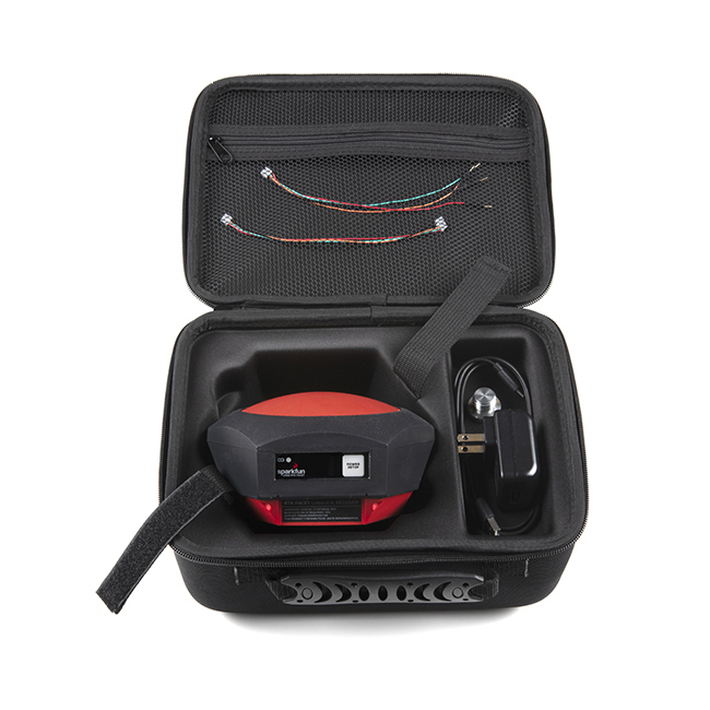
Note: The SparkFun RTK Facet is just the enclosed device with thread adapter, charger, data cables, and carrying case. It does NOT include serial telemetry radio or associated mounting poles. These items will need to be purchased separately.
Includes:
- 1x SparkFun RTK Facet
- 1x SparkFun RTK Facet Carrying Case
- 1x Antenna Thread Adapter - 1/4in. to 5/8in.
- 1x Breadboard to GHR-04V Cable - 4-Pin x 1.25mm Pitch
- 1x GHR-04V to GHR-06V Cable - 1.25mm pitch
- 1x USB A to C Cable - 0.8m
- 1x USB Wall Charger - 5V, 2A
Features:
Overall Device
- Enclosed Facet Design IP53 - Protected from limited dust ingress and water spray
- Internal Antenna: L1/L2 with ≥5dBi gain
- Internal Battery: LiPo 6Ah with fast 1 amp charging
- Radio Port: 3.3V TTL Serial (57600bps RTCM TX/RX)
- Data Port: 3.3V TTL Serial (115200bps NMEA)
- Qwiic Port: Supports I2C based add-on devices
- microSD: Compatible up to 32GB
- Embedded OLED Display for positional accuracy, available satellites, data logging, etc.
- Single push button control
- Weight: 583g (1.3 lbs)
- Dimensions: 136mm x 146mm x 80mm (5.35in x 5.74in x 3.14in)
- Works with common GIS software including: SW Maps, SurvPC, Field Genius, et al.* Open Source Hardware Certified Project
- Manufactured in Boulder, CO USA
GNSS Receiver: ZED-F9P
- Concurrent reception of GPS, GLONASS, Galileo, and BeiDou
- Receives both L1C/A and L2C bands
- 184-channel u-blox F9 engine
- Current: 68mA - 130mA (varies with constellations and tracking state)
- Time to First Fix: 25s (cold), 2s (hot)
- Max Navigation Rate:
- PVT (basic location over UBX binary protocol) - 25Hz
- RTK - 20Hz
- Raw - 25Hz
- Horizontal Position Accuracy:
- 2.5m without RTK
- 0.010m with RTK
- Max Altitude: 50km (31 miles)
- Max Velocity: 500m/s (1118mph)
Bluetooth® Transceiver: ESP32 WROOM
- Xtensa® dual-core 32-bit LX6 microprocessor
- Up to 240MHz clock frequency
- 16MB of flash storage
- 520kB internal SRAM
- Integrated 802.11 BGN WiFi transceiver
- Integrated dual-mode Bluetooth® (classic and BLE)
- Hardware accelerated encryption (AES, SHA2, ECC, RSA-4096)
- 2.5 µA deep sleep current
Documents:
- Schematics:
- Hookup Guide
- ZED-F9P Datasheet
- What is Qwiic?
- Building a GNSS System
- Learn More About RTK Surveyors
- GitHub Firmware Repo
- GitHub Hardware Repo
- Open Source Certified Hardware: US002064
Videos
| Manufacturer | SparkFun |
|---|


